Thanks to progress and digitisation, photogrammetry, once a traditional land surveying method and a science of making measurements from photographs, has been applied in a number of fields, from architecture and civil engineering to industry, medicine, forensics, biology and chemistry.
As technologies developed, photogrammetry split into several specialised areas. The division criteria include the distance of the sensor from the object at the time of capturing the image, according to which photogrammetry can be divided into microscope, close-range, aero and satellite photogrammetry. While the methods of aero and satellite photogrammetry are mostly used to determine the shape of the Earth’s surface and measure phenomena found on it, close-range photogrammetry is used to measure the shape and geometric characteristics of mostly smaller objects, whereby photos of such objects are taken from a smaller distance, typically from less than 300 m.
In close-range photogrammetry, digitisation has enabled the automation of capturing and measuring objects, thus expanding the applicability of the method in numerous fields:
- In civil engineering, it is used to obtain a precise and realistic geometric model of new or existing engineering objects, roads, buildings or parts thereof, enabling engineers to save time and money when making geometric models, especially when complex geometry is involved, or if the object in question is difficult to access.
- In architecture, archaeology and preservation of cultural heritage, it enables obtaining digital documentation with measurements taken of the already existing objects. This makes it possible to draw up plans and prepare geometric data for mathematical models for static and dynamic analyses, assessments of situations, planning renovations, adaptations, upgrades – all this with contactless measuring that does no harm to the culturally protected objects.
- In industry, photogrammetry assists in fulfilling the need for precise and fast measuring of designed products and mechanical elements in order to shorten production time, improve the production process, reduce the amount of waste and check the quality of production.
- In forensic science, the methods of close-range photogrammetry are applied to reconstruct accidents, crime scenes, and identify people and evidence.
- In medicine, the advantages of close-range photogrammetry come to the forefront when measuring forms to make prosthetics, determining microgaps, and assessing changes after procedures of cosmetic surgery and dental orthopaedics; they are also valuable when it comes to detecting and measuring skin changes, examining deep and wide wounds, assessing spine curvature, analysing posture and movement etc.
The camera is still the most frequently used sensor in photogrammetry. Up until recently, the prevalent belief was that professional photogrammetry requires capturing high-quality data for subsequent, highly accurate spatial calculations by means of special, i.e. metric cameras, which are designed for the specific purpose of photogrammetric shoots. Upon purchasing such a camera, the buyer receives a calibration certificate that contains the data necessary for further photogrammetric procedures (i.e. precise focal length, coordinates of fiducial marks defining the coordinate system of the image, radial distortion of the lense, resolution etc.). Although the calibration certificate is drawn up by the manufacturer, it requires periodic updates and controls.
With successful development of digital technologies, the market was able to offer a wide range of top-quality and affordable non-metric digital cameras, which are gradually becoming an alternative to expensive metric cameras. Non-metric cameras use zoom focus lenses and feature unstable and frequently unknown elements of internal orientation. Because of their simple use, a unified image coordinate system determined by the matrix of pixels and their increasing geometric resolution, they are nevertheless becoming more and more appealing for the tasks of close-range photogrammetry where the measurements don’t need to be absolutely accurate.
Photogrammetric methods are usually based on stereoscopic observation. In such cases, specialised hardware and software is required to orientate a stereopair of shots and generate 3D models for observation and measuring. Professional equipment is relatively expensive and requires expertise in order to deliver quality results.

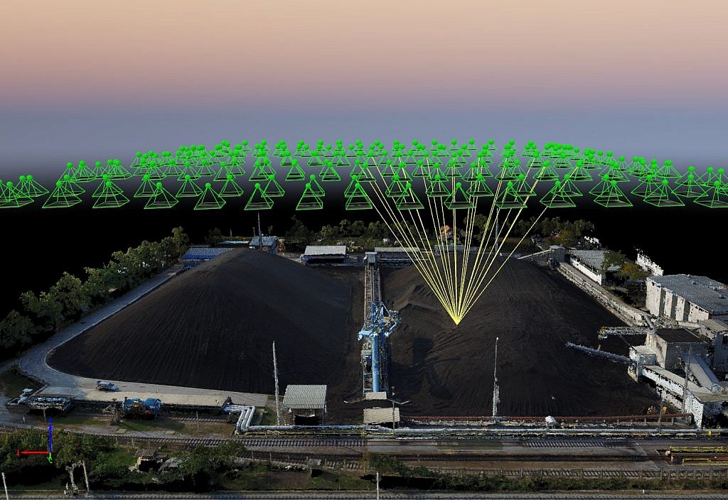
Point cloud, obtained from aerial photos, captured by non-metric digital camera,
and processed by applying the close-range photogrammetry algorithms.
The yellow lines represent the connections among point position on the ground of its positions on the aerial photos.
In recent years, the SfM method (i.e. structure from motion) revolutionised close-range photogrammetry. The method enables effective creation of 3D models from ordinary photos, without expensive and complex professional equipment. Although the SfM method is based on the same basic principles as stereoscopic photogrammetry (using a pair of overlapping photos captured from two different perspectives), it differs from it fundamentally in that, unlike non-metric cameras, the camera can be calibrated automatically, without a reference grid of points with known 3D coordinates. With this method, it is sufficient to use one camera to capture a series of photos of a static object, with a high degree of overlapping. The great advantage of the method is that it requires no prior information as to when and where the images are to be captured, nor regarding the camera itself. We can thus use ordinary digital cameras or even older cameras with no known information on said camera or the capture parameters. In land surveying and topography, the method grew alongside the development of affordable robotic aircrafts, which can take photos of the Earth’s surface in a suitable raster, so that the photos overlap at an optimum. This way, the creative leap shifted back to the initial branch of science which began charting the Earth’s surface by means of aerial photos nearly 100 years ago.
